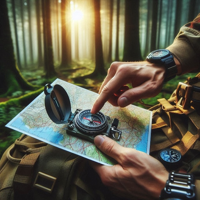
Hitting the trails without digital assistance sounds daunting, but traditional trail navigation is a skill worth mastering. Navigating with just a map and compass brings a sense of self-reliance and awareness of your environment. Imagine navigating through the vast wilderness, feeling confident despite having no signal or battery on your device.
Dependence on GPS devices can lead to a false sense of security. Electronics can fail due to dead batteries, poor signal, or technical glitches. When this happens, strong traditional navigation skills can be a lifesaver. Learning to read a map, use a compass, and understand the landscape puts you in control.
Consider the stories from seasoned hikers and outdoor enthusiasts who often speak about their experiences of being saved by their navigation skills when their tech failed. They talk about the peace of mind they get from knowing they can rely on their abilities rather than gadgets.
There’s also the issue of fostering a deeper connection with nature. When you’re not constantly checking a device, you spend more time observing and appreciating your surroundings. You notice the subtle shifts in the terrain, the positions of the sun and stars, and the directional flow of rivers and winds. These observations become your guides, offering insights into your next steps.
Learning and practicing traditional navigation techniques before hitting the trail is essential. They build confidence, promote safety, and enhance the overall hiking experience. Finding your way using just your wits and natural cues is an empowering feeling, not to mention a vital skill in case of an emergency.
Preparing for Your Hike: Essential Tools and Resources
Preparation is key before setting foot on any trail. Knowing what tools and resources to bring can make the difference between a smooth and precarious hike.
At the top of the list are maps and a compass. These are the bread and butter of traditional navigation. Invest in high-quality topographical maps of the area you plan to hike. They give detailed information about terrain, elevations, and water sources. Pairing these maps with a reliable and easy-to-read compass will set a solid foundation for navigating the trails.
Understanding how to read these topographical maps is crucial. Look at the contour lines that indicate elevation changes. The closer the lines, the steeper the terrain. Learn to identify key features like valleys, ridges, and streams. These elements will help you plan your route and anticipate the physical demands of your hike.
Other tools can also be useful. An altimeter, for instance, measures altitude and helps confirm your position by matching the data with your map. Simple markers, like brightly colored tape, can be used to mark significant places or reference points along your route.
Guidebooks and local trail guides can also provide valuable insights. They often contain detailed descriptions of trails, notable features, and potential hazards. These resources supplement your maps and compass, offering a fuller picture of what to expect on your hike.
Preparation isn’t just about having the right tools and knowing how to use them effectively. Spend time practicing at home or in a local park. Familiarize yourself with the tools and get comfortable using them before your big adventure. Solid preparation will ensure your safety and enrich your hiking experience.
Mastering Map Reading: Understanding Symbols and Scales
Reading a map is an art form. The key to mastering it is understanding the symbols and scales used to represent the terrain. These maps are rich in detail but can be overwhelming without some basic knowledge.
One essential is knowing what the various symbols and colors mean. Different shades of green might indicate forested areas, while blue lines usually represent rivers and streams. Icons can point out man-made structures like roads, trails, and buildings. Contour lines, which show elevation, are crucial. Close lines mean steep terrain, while widely spaced lines suggest a gentler slope.
Scales on maps help determine real-world distances. A common scale might be 1:25,000, meaning one unit on the map equals 25,000 of those units in real life. This scale is helpful for detailed navigation. Using a ruler or the scale provided on the map helps estimate distances between points, helping you plan your route more effectively.
Grid references are another tool for precision. Maps often feature a grid system, allowing you to pinpoint exact locations. Latitude and longitude lines provide global positioning, while the grid helps with local orientation.
Practice using these elements together. Start by identifying where you are on the map using prominent landmarks around you. Then, trace your path to your next point of interest, considering the terrain and distance. Linking these skills together makes the map powerful in your navigation toolkit.
Using a Compass: Finding Your Bearings
A compass is more than just a needle pointing north; it’s a fundamental tool for accurate navigation. Understanding how to use it can make all the difference on a trail.
In compliance with the FTC guidelines, please assume the following about links and posts on this site: Any/all of the links fourseasonshiking.com are affiliate links, of which I receive a small compensation from sales of certain items.
First, learn about the compass parts: the baseplate, the rotating compass housing, the direction of travel arrow, and the magnetic needle. This knowledge will help you use the tool effectively.
One of the primary techniques involves taking a bearing. To do this, align the compass baseplate with the map’s direction of travel. Rotate the compass housing until the orientation lines match the map’s north. Then, turn yourself until the magnetic needle fits into the orienting arrow. This alignment shows your direction of travel.
Following a bearing helps maintain an accurate route, especially in areas without clear trails. It keeps you on track, even through dense forests or across open fields.
Another essential technique is triangulation. This method helps determine your exact location by taking bearings of at least two, preferably three, landmarks. Draw lines from these points on your map; where they intersect is your position. This practice is especially useful when you need to confirm your location mid-hike.
Regularly checking your bearings ensures you stay on course. Make it a habit to stop and verify your direction, especially after breaks or significant changes in the landscape. Taking small steps like these can help you navigate your adventure confidently.
Natural Navigation: Leveraging the Environment
Nature is a reliable guide if you know what to look for. Using natural navigation techniques can be incredibly useful, especially when your tools fail or aren’t handy.
The sun is one of the most obvious natural landmarks. It rises in the east and sets in the west, providing a general direction throughout the day. It’s usually south at noon if you’re in the Northern Hemisphere. On clear nights, the North Star offers a constant point of reference. In the Southern Hemisphere, the Southern Cross constellation serves a similar purpose.
Reading the landscape itself can provide clues. Rivers often flow from higher to lower elevations; following a river downstream can lead you to civilization or known water bodies. Ridge lines can be followed to higher ground, offering a better vantage point.
Vegetation also offers subtle hints. In many regions, moss tends to grow on the north side of trees because it’s shadier and moister. However, this isn’t a foolproof strategy, so use it in conjunction with other methods.
Observing animal behaviors can provide additional insights. Birds typically fly towards water sources during certain times of the day, and animal trails often lead to water or food sources. Even wind patterns can help; coastal winds usually blow inland during the day and out to sea at night.
Incorporating these natural navigation methods into your hiking routine enhances your connection to the environment and provides an additional layer of safety. These cues become second nature with practice, empowering you to navigate confidently even without modern tools.
Safety Tips and Common Mistakes to Avoid
Safety should always be your top priority when hiking, especially when navigating without GPS. Start with fundamental safety precautions like telling someone your plans, including your expected route and return time. This information can be invaluable in case of an emergency.
Maintain a sense of situational awareness at all times. Weather can change rapidly, altering the landscape and complicating navigation. Carry appropriate gear for unexpected weather conditions, such as rain jackets and extra layers.
Hydration and nutrition are critical. A premium water filtration system can ensure proper hydration. Dehydration and fatigue can impair judgment and make navigation more challenging.
One common mistake is over-relying on a single method of navigation. Diversify your techniques by combining map reading, compass use, and natural navigation cues. This strategy provides a more robust and flexible approach to finding your way.
Another pitfall is failing to practice your navigation skills regularly. Even seasoned hikers need to brush up on these skills periodically. Use local parks or familiar trails as practice grounds.
In case you do get lost, staying calm is crucial. Panicking can lead to poor decisions. Use the STOP method: Stop, Think, Observe, and Plan. Reassess your surroundings and consult your map and compass to reorient yourself.
Lastly, prepare for the unexpected by carrying an emergency kit that includes items like a whistle, fire starter, and reflective blanket. These tools can be lifesavers if you find yourself in a difficult situation.
Thanks for the really insightful article. As a keen hiker myself, you have hit the nail on the head with the importance on not just relying on technology but having map reading and navigation skills. So often phone batteries die or there is no network and relying on navigation skills can be lifesaving. It is a great skill to have and makes you more aware of your surroundings.
Hi, thank you. I appreciate the comment, especially from experience. In the mountains, there may be a signal, until you cross over the next mountain.
Lonnie
This is a timely article as we prepare to do some traveling and hiking. I much prefer traditional trail navigation even in this digital age. A map and compass work just fine without the false sense of security. Also, understanding the landscape is a part of the total experience along with connecting with the natural environment. I appreciate you providing the essential tools and resources. Your safety tips and things to avoid are also essential things to know. I now feel much more prepared as we venture out into the wilderness.
Thank you, I’m glad the article was timely for you. Have a great hike!
Lonnie